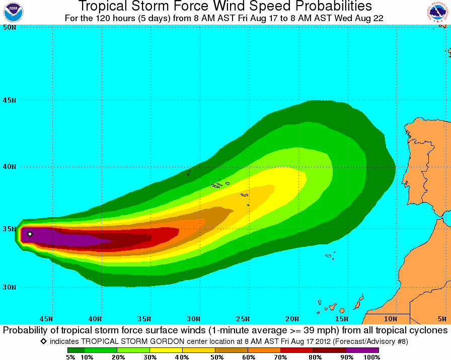
A mid-Atlantic Tropical Storm is forecast to approach The Azores late on Sunday before tracking east to affect Spain and Portugal as an extra-Tropical Storm during the middle of next week. The system will not affect the UK or Ireland.
Tropical Storm Gordon, the 7th named storm of the Atlantic Hurricane Season, is currently located 1770 kilometres west of The Azores and is moving east at 3o km/h. Maximum sustained winds of 100 km/h have been recorded while the system’s minimum central pressure is 997mb.
The Miami-based U.S. National Hurricane Centre (NHC) says that some slight strengthening of the system is expected during the next day or so before it reaches cooler waters, east of The Azores.
 |
| This ogimet.com GFS pressure chart shows Gordon shortly before it becomes an ex-tropical storm late Tuesday into Wednesday. |
Michael Brennan, NHC Senior Hurricane Specialist commented on Friday evening: “The satellite appearance of Gordon remains rather unimpressive with cloud top temperatures warming over the past few hours and the coldest cloud tops displaced north and west of the center. The shear is forecast to decrease a little in the short term, which should allow Gordon to strengthen a bit before the cyclone reaches sub-26c waters and the shear increases in 36 to 48 hours. The NHC forecast shows the cyclone peaking at 60 kt in 24 to 36 hours.”
Mr. Brennan noted that Gordon would not become a hurricane this weekend, despite indications from the NHC on Thursday that significant strengthening of the system would occur late on Friday and during Saturday.
“Gordon will be steered generally eastward for the next day or so to the south of a large mid/upper-level trough over the northeastern Atlantic. By late Sunday, a shortwave trough is expected to approach the cyclone from the west and induce an east-northeastward turn as the cyclone becomes extratropical in about 3 days. A slow east-northeastward motion is expected at days 4 and 5 as the cyclone weakens. Overall the track model guidance remains in good agreement on this scenario,” added. Mr. Brennan.
Elsewhere in the Atlantic, a tropical wave located just west of the coast of Africa continues to produce an area of disorganized showers and thunderstorms in the far eastern atlantic ocean. some slow development of this system is possible during the next few days. This system has a low chance (10 percent) of becoming a tropical cyclone during the next 48 hours as it moves toward the west at 15 to 20 mph.
TROPICAL STORM GORDON PROJECTED PATH


